
Ottawa’s new zoning by-law treats the whole city as one rulebook. The lots don’t read that way. A 60-foot suburban frontage in Kanata and a skinny streetcar-era lot in Old Ottawa South both allow more than one unit now, but they ask for completely different buildings. The map tells you what’s permitted. The lot tells you what fits. This is a tour of five Ottawa neighbourhoods through that second lens — lot character and transit, not price.
TL;DR
- Ottawa’s Zoning By-law 2026-50 (enacted March 11, 2026) allows up to four units as-of-right on a serviced lot, with size-based neighbourhood zones (N1 through N4). N1 caps around 4 units, N2 around 6, N3 around 10. Higher zones sit near transit and main streets.
- Parking minimums were removed city-wide. That changes what a small multiplex can fit, especially on tight inner lots.
- Ontario’s Bill 23 sets a province-wide floor of three units per lot.
- Where a multiplex pencils depends on your N-zone and your lot dimensions — not on what the neighbourhood is “worth.”
- Confirm your parcel’s zone and frontage on geoOttawa before you do anything else.
How to read this tour
The same by-law covers all five neighbourhoods below. What changes is the lot. A wide suburban lot gives you room to build a side-by-side fourplex with surface parking. A narrow inner lot pushes you toward a stacked or back-to-back layout, and the removal of parking minimums is what makes that layout viable. Transit matters because the higher N-zones cluster near O-Train stations and main streets, and that’s where unit counts climb.
Two numbers decide most of it: your N-zone and your frontage. Pull both from geoOttawa and read the zone rules at Ottawa’s zoning portal. What follows is the pattern, not the parcel.
Kanata
Kanata sits about 22 km west of downtown along Highway 417, split into Kanata North and Kanata South wards by the highway itself. It was planned in the 1960s as a suburban community, and the lots show it: wide frontages, deep setbacks, detached homes on generous parcels.
That lot character is the opportunity for a multiplex builder. Wide frontage means a side-by-side fourplex or a pair of semi-detached units can sit on one lot without fighting the geometry. You have room for surface parking even though the by-law no longer forces you to provide it. The west tech corridor — Kanata North Business Park, one of Canada’s largest technology parks with hundreds of companies — drives steady rental demand from people who’d rather live near work than commute from the core.
The catch in Kanata is transit. There’s no O-Train station here, so you won’t find the higher N-zones that cluster around rail. Most Kanata residential land reads as lower-density neighbourhood zoning. Confirm whether your lot is N1 or N2 before you assume more than four units. More on lot-by-lot screening on the Kanata hub page.
Barrhaven
Barrhaven is the south-end story. It sits about 17 km southwest of downtown, was part of the old City of Nepean before amalgamation, and grew fast — newer subdivisions like Stonebridge and Half Moon Bay turned it into a community of over 100,000 people. It’s divided into Barrhaven West and Barrhaven East wards.
For a multiplex, Barrhaven looks a lot like Kanata in its lot geometry: newer subdivision lots, regular shapes, suburban frontages. The build that fits is the same family — side-by-side units, semis, a fourplex that uses the width of the lot. The advantage of newer subdivisions is that servicing is modern and the parcels are predictable, so what you see on the survey is usually what you get.
The same transit caveat applies. Barrhaven is a bus-served suburb, not a rail one, so the higher N-zones won’t show up the way they do near an O-Train line. That keeps most lots in the lower-unit-count bands. Check your zone on geoOttawa rather than assuming the subdivision allows what the by-law permits at its ceiling. See the Barrhaven hub page for the parcel detail.
Orléans
Orléans changes the math because of the train. The O-Train East Extension runs Line 1 from Blair to Trim, adding five stations — Montréal, Jeanne d’Arc, Orléans Boulevard, Place d’Orléans, and Trim — across 12.5 km through Orléans, Blackburn Hamlet, and Beacon Hill. That puts a large slice of the east end within a few kilometres of light rail.
This is where the higher N-zones earn their place. Ottawa’s by-law concentrates more density near transit, so lots within walking distance of those new stations are the ones most likely to carry an N3 designation — meaning a multiplex of roughly ten units rather than four. That’s a different building and a different proforma than the suburban fourplex.
Orléans has a mix of lot types. Older sections near the original village have tighter, more varied lots; the newer subdivisions to the south read like Barrhaven. The play here is to find the station-adjacent parcels where zone and frontage line up. Confirm the station-area zoning on OC Transpo’s O-Train East page and the parcel itself on geoOttawa. The Orléans hub page breaks down which pockets carry the higher zones.
Old Ottawa South
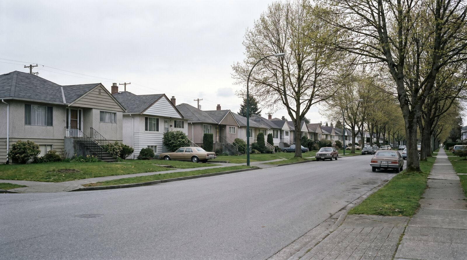
Old Ottawa South is the opposite of Kanata in almost every way that matters to a builder. It’s an older urban neighbourhood in Capital Ward, wedged between the Rideau Canal and the Rideau River, with Bronson Avenue on the west and Avenue Road on the east. The streetcar built it — the Bank Street line crossed the canal in 1913 and the neighbourhood filled in around it. The lots are narrow, the streetscapes are tight, and much of the original housing is still standing.
Narrow streetcar-era lots don’t take a side-by-side fourplex. They take infill — a stacked layout, a back-to-back design, or a careful three-to-four-unit building that works with the depth of the lot rather than its width. This is exactly where removing parking minimums changes the answer. On a skinny inner lot, the old requirement to provide parking often killed the unit count before you started. Without it, a fourplex on a narrow lot becomes buildable.
Old Ottawa South has seen relatively little high-rise development but increasingly common modern infill, so the pattern is established. The constraint is heritage character and lot width, not zoning ambition. Read your frontage carefully on geoOttawa — a few feet of width decides which layouts are even worth drawing. The Old Ottawa South hub page covers the infill detail.
Westboro
Westboro is the inner-west premium-infill case. It runs along the Ottawa River west of downtown, sits in Kitchissippi Ward, and is genuinely walkable — a Walk Score of 87, with Richmond Road’s shops and cafés as the spine. The O-Train serves it: Dominion Station sits in the heart of the neighbourhood, with the western Line 1 extension building toward Westboro Station at the edge.
That combination — walkability plus rail — is why Westboro carries strong infill demand. The housing stock is a mix of century homes and modern infill, and builders here already replace single lots with multi-unit buildings. Lots tend to be inner-city width: narrower than the suburbs, wider than Old Ottawa South’s tightest streets, often somewhere in between.
The transit access means some Westboro lots, particularly near the stations and along the main streets, can land in higher N-zones than a comparable suburban parcel. That’s the lever. A multiplex near Dominion Station is working with both the rental demand of a walkable neighbourhood and the unit-count room of a transit-adjacent zone. Confirm the zone on geoOttawa — Westboro’s mix means two lots a block apart can read very differently. The Westboro hub page has the parcel-level breakdown.
The honest part
None of this is a guarantee. A favourable N-zone tells you what’s permitted; it doesn’t tell you that the numbers work after land, construction, and financing. A wide Kanata lot might allow a fourplex and still not pencil if land costs eat the return. A station-adjacent Orléans lot might carry an N3 and still need a layout that fits the parcel before it fits the spreadsheet. Zoning is the floor, not the answer.
The two things that actually decide it are the same in every neighbourhood: your exact N-zone and your exact lot dimensions. Both are public. Both are on geoOttawa. Pull them before you talk to anyone.
If you want to see how the unit count, build cost, and return line up on a specific Ottawa lot, that’s what the feasibility tool is for. And if you’re new to the by-law, start at the hub: Missing Middle Housing in Ottawa.
Sources
- City of Ottawa, geoOttawa parcel map.
- City of Ottawa, zoning by-law engagement portal.
- OC Transpo, O-Train East extension — lines and stations.
- Neighbourhood character and ward details: Wikipedia entries for Kanata, Barrhaven, Old Ottawa South, and Westboro; OC Transpo station pages.
David Babakaiff is Co-Founder of VanPlex. Missing Middle in Ottawa | Build with the by-law, not against it.